The best Garmin hiking and navigation apps
The best hiking app this week is Awesome Maps (Free Topo Map & Routes + Offline) by CrispGarmin (Free trial, score 8.1/10). Topo, satellite and national maps on your watch even without built-in map support, streamed from your phone, with route following and an offline mode.
Apps and data fields for hiking and finding your way: maps, routes, compass, altitude and outdoor tools.
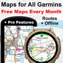
Awesome Maps (Free Topo Map & Routes + Offline)
Topo, satellite and national maps on your watch even without built-in map support, streamed from your phone, with route following and an offline mode. Includes many national map services worldwide.

RuckTrack — Rucking, Treadmill, Weighted Vest
Tracks rucking, weighted-vest walks and loaded hikes, indoors or out, and calculates calories with the Pandolf load-carriage equation from pack weight, speed, grade and surface. Pack weight, ruck calories and burn rate are saved to Garmin Connect.

Maps4Garmin (Free) with Weather Radar (Paid)
Free live maps on your watch with no sign-up: see your location and browse the area around you. An optional yearly license adds a weather radar.

komoot
The komoot app for Garmin: plan routes with community recommendations, then find and navigate your planned tours on your watch in a few taps, with accurate way, surface and elevation info.
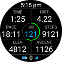
HikeField v2
An all-in-one data field for hiking and walking: a circle shows how much daylight you have left until sunset, plus many hike-related values. A revived and extended version of the original HikeField.
Peak Finder Compass
A live compass panorama: names of peaks and alpine huts float above the ridgeline as you face them, within 75 km anywhere in the world. Works offline with cached OpenStreetMap data and can navigate to a chosen peak.
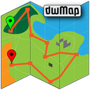
dwMap
An award-winning maps and routes app: create a route on your phone or laptop, send it to your watch and navigate it without a data connection. All described features are free; premium adds more.
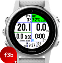
F3b Dozen Walk
A 12-value data field for walkers and hikers that shows both speed and pace and your total activity steps.
Cacher (Geocaching)
Geocaching on your watch: search caches near you, read their descriptions, see size, difficulty and terrain on a map, follow the distance and direction, log finds and record the hunt as an activity.
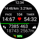
Hiker DF
A data field for hikers from an experienced developer who welcomes feedback, with the values that matter on the trail.

PackCal
Computes the calories that carrying a load really costs, from physics rather than heart rate: for weighted-vest walks, loaded hikes, rucks or a child in the carrier. A one-cell data field.

AllTrails: Hike, Bike & Run
Brings your saved AllTrails trails and routes to the watch: browse nearby trails, favourites, lists and custom routes, download one and follow it with the watch's own course navigation. Needs an AllTrails Plus or Peak membership and a linked Garmin Connect account.
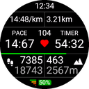
Hiker App
A hiking app for your watch from an experienced Connect IQ developer who answers feedback personally and keeps improving it. Records your hikes with the data that matters on the trail.
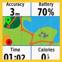
mapField
Shows your route as a map inside a data field, so it sits on any data page of the built-in Run, Bike or Hike activities, and on Edge devices even on the elevation or ClimbPro pages. Activation is free; premium features are paid.
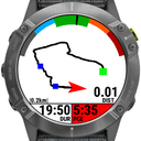
MapIT
A data field that draws the trail you have already travelled, with customisable and removable fields, so you do not get lost on runs, walks or rides in new areas. Press pause twice within 5 seconds to zoom.
Scores 0–10 from description, rating, popularity, recent reviews, care, reach and originality; template series and duplicate trial editions are filtered out. How we rate →